On May 22, 1960 a gigantic earthquake struck off the coast of southern Chile. The quake inflicted $550 million (more than $4 billion in current USD) of damage in Chile alone[1] and triggered a massive tsunami that affected communities around the entire Pacific Ocean. With a magnitude (M) of 9.5, the 1960 Chilean earthquake is the largest earthquake to ever have been recorded. It released over 1 billion times as much energy as the Hiroshima atomic bomb.
Large-magnitude earthquakes are immensely more powerful than small-magnitude earthquakes. The magnitude scale is logarithmic. One unit of magnitude (e.g. going from M8.0 to M9.0) is equivalent to a 32-fold increase in energy. Hence, a M9.0 earthquake is 32 times stronger than a M8.0 quake, 1024 (32×32) times stronger than a M7.0 quake, and over 1 trillion times stronger than a M1.0 quake. The quick ramp up of energy with increasing earthquake size explains why large earthquakes are so much more destructive than small ones.
Earthquakes occur on big cracks in the ground called faults. Over time, pressure builds up on the fault and eventually causes the sides of the fault to slip past each other, creating an earthquake. Why was the earthquake in Chile exceptionally large? Big earthquakes require big faults. The 1960 Chilean earthquake occurred on a section of fault approximately 550-600 miles long[2], the length of the Oregon and Washington coast. The M9.0 earthquake in Japan in 2011 occurred on a 300-mile-long fault segment[3]. Earthquake magnitude scales with fault length; larger faults are capable of producing larger earthquakes. This concept is similar to how a big house requires a big lot, or how your friend with the most floor space can host the biggest dance party. Consequently, smaller earthquakes happen on smaller faults. For example, the M6.9 1989 Loma Prieta earthquake (also known as the World Series earthquake) near San Francisco occurred on a 20-mile-long section of the San Andreas Fault.[4]
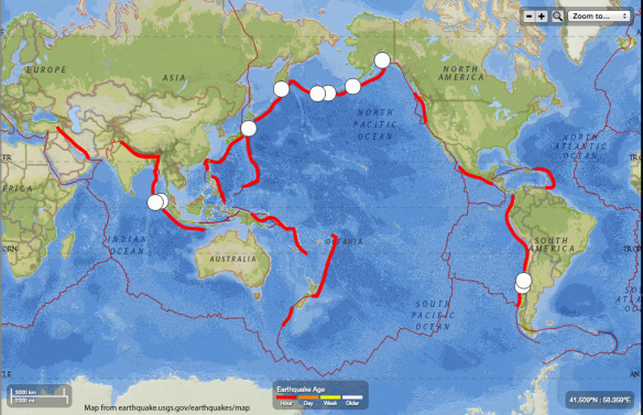
There are many faults in the world capable of producing monster earthquakes. Both the 1960 Chile and 2011 Japan earthquakes occurred on a type of plate boundary, called a subduction zone, where the heavier of two colliding tectonic plates dives beneath the other. Subduction zones make up the largest faults in the world, and hence have the real estate to host the biggest quakes. The ten largest quakes since 1900, all M8.6 or above, happened in subduction zones. The locations of these quakes (white dots) and subduction zones (thick, red lines) are shown on the map below. The thick, red line on the west coast of the United States is the Cascadia Subduction Zone, where the Pacific Northwest “big one” is going to occur.
Could there be an earthquake even larger than the Chilean quake? We cannot definitively rule out that possibility. The fault section that moves, or ruptures, during an earthquake is often shorter than the length of the entire subduction zone. Therefore it is possible for a larger segment of the fault to rupture. The Chilean quake only broke a small portion of the 3600-mile long Peru/Chile subduction zone. If the entire subduction zone ruptured at once, you could get a much bigger quake. But, a full rupture of a fault that big is highly unlikely.
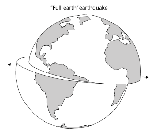
There is an absolute limit on earthquake magnitude because of the size of the Earth. An earthquake that split the Earth in half (creating a fault with length equivalent to the Earth’s diameter, or just less than 8,000 miles) would be larger than M10. Though I cannot say that a full-subduction-zone earthquake is not possible, I can say with confidence that a “full-earth” earthquake will not happen.
[1] “Southern Chile Earthquake and Tsunami, 22 May 1960.” Southern Chile Earthquake and Tsunami, 22 May 1960. NOAA: National Centers for Environmental Information, n.d. Web. 27 June 2016. https://www.ngdc.noaa.gov/hazard/22may1960.html.
[2] Barrientos, Sergio E., and Steven N. Ward. “The 1960 Chile earthquake: inversion for slip distribution from surface deformation.” Geophysical Journal International 103.3 (1990): 589-598.
[3] Ammon, Charles J., et al. “A rupture model of the 2011 off the Pacific coast of Tohoku Earthquake.” Earth, Planets and Space 63.7 (2011): 693-696.
[4] “The Loma Prieta, California, Earthquake of October 17, 1989—Main Shock Characteristics.” The Loma Prieta, California, Earthquake of October 17, 1989. Ed. Paul Spudich. United States Geological Survey, 1996. Web. 27 June 2016. http://pubs.usgs.gov/pp/pp1550/pp1550a/.
